


The Process
Hundreds of photos.
One measurable map.
Keep scrolling to go from the sharpest free map view of this field to our drone orthomosaic, with detail up to 0.6 inches per pixel: sharp and accurate enough to measure distances, areas, and volumes.


01 / 06
Drone Mapping & 3D Modeling
Every acre, measured.
Georeferenced orthomosaics and elevation models of parcels, fields, and job sites for drainage, grading, and site design, with sub-inch detail when flown at 300 feet or lower.
- GeoTIFF orthomosaic
- DSM & contours
- KMZ for Google Earth

02 / 06
Construction Progress Mapping
Watch the site take shape.
Scheduled flights build a visual timeline for owners, PMs, and lenders, from dirt work to final walk-through.
- Weekly / monthly maps
- Cut & fill comparisons
- Progress photo sets

03 / 06
Roof & Structure Inspections
Look closer. Stay grounded.
Roofs, structures, bins, towers, and pivots inspected from the air, with no ladders, lifts, or downtime.
- Roofs & envelopes
- Bins & structures
- Annotated photo report

Sample model
04 / 06
Stockpile & Silage Volumes
Know what’s in the pile.
Silage, gravel, sand, and aggregate measured from 3D models. It's faster, safer, and more repeatable than walking the pile.
- Cubic yards / tons
- Repeatable inventory
- PDF volume report
05 / 06
Agriculture & Crop Imaging
See the whole field at once.
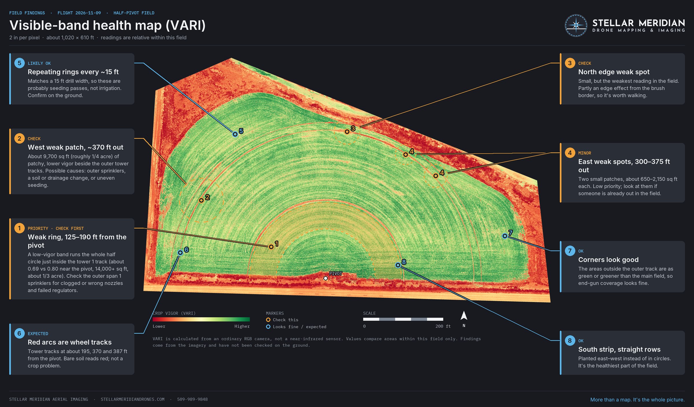
Spot irrigation problems, stand gaps, and stress patterns early with field-wide imagery and visible-band health maps.
- Field orthomosaics
- Visible-band health maps
- Pivot & drainage checks

06 / 06
Aerial Photo & Video
Show the whole property.
Hasselblad-sensor stills and cinematic 4K video for real estate, farms, events, and marketing.
- Edited high-res stills
- 4K video & short edits
- Real estate & land listings

Recent Work
From the field.
Orthomosaics, volume models, and imagery from around the Columbia Basin.


About
Local pilot. Technical eye. Straight answers.
I'm Trevor Darlington, an FAA Part 107 certified drone pilot based in Moses Lake. I started Stellar Meridian to give local builders, landowners, and growers fast access to aerial data that used to take a survey crew or a manned aircraft. I fly a variety of FPV and gimbal drones and process every project myself, so you deal with one person from the first call to the final map.
More than a map.
It’s the whole picture.
- FAA Part 107 certified remote pilot
- Based in Moses Lake, serving Grant, Adams & surrounding counties
- Airspace-aware, with LAANC authorization and pre-flight planning on every job
Service areaMoses Lake · Ephrata · Quincy · Othello · Royal City · Warden · Soap Lake · Ritzville · and beyond on request
Request a Quote
Tell me about your site.
Share the basics and I'll follow up within one business day with pricing and scheduling. Not sure what you need? Describe the problem and I'll recommend a deliverable.
- Tell me about the siteWhere it is, what you need measured or captured, and any deadline.
- I plan the flightAirspace check, LAANC authorization when needed, and a clear quote.
- You get the deliverablesMaps, models, reports, or photos in formats you can use.
Questions
Common questions
What areas do you serve?
I'm based in Moses Lake and fly across Grant and Adams counties, including Ephrata, Quincy, Othello, Royal City, Warden, Soap Lake, and Ritzville. Jobs farther out in Central Washington are available on request.
Are you licensed to fly drones commercially?
Yes. I'm an FAA Part 107 certified remote pilot. Every job gets pre-flight planning and an airspace check, with LAANC authorization when the site is in controlled airspace.
What do I get from a mapping flight?
A georeferenced orthomosaic (GeoTIFF), an elevation model (DSM) with contours, and a KMZ file that opens in Google Earth. If you're not sure which you need, describe the job and I'll recommend the right deliverables.
How sharp are your maps compared to free online aerial photos?
Much sharper. The sharpest free aerial view of the field shown on this site is about 24 inches per pixel. Our Mavic 3 Pro captures detail up to 0.6 inches per pixel when flown at 200 feet (about 1.3 inches at the 400-foot ceiling), so maps can be delivered at the detail the job needs.
How do you measure stockpile and silage volumes?
The drone flies over the pile and the overlapping photos are processed into a 3D model. The volume is calculated from that model and reported in cubic yards or tons, with a PDF volume report. It's faster, safer, and more repeatable than walking the pile.
Can a drone show crop health problems?
Yes. Field-wide orthomosaics and visible-band (VARI) health maps make irrigation problems, stand gaps, and stress patterns easy to spot across the whole field at once.
How much does a drone job cost?
Every job is quoted for its site and the deliverables you need. Send the basics through the form or email trevor@stellarmeridiandrones.com, and I'll follow up within one business day with pricing and scheduling.